Saturday, April 30, 2011

Day 30 - Deer Park Shelter to Hot Springs - 3 miles

We phone a B&B in Hot Springs from the campsite before we start hiking, but they have no vacancy. There is a music festival in town for the weekend and all the accommodation is full. Trust us to arrive at such a time. We start hiking and 30 minutes later, our phone rings. It is Duckett House to say they have had a cancellation so we book a room for 2 mights. We are amazed at our good luck - that we left the phone switched on, that we were on a ridge, so we had reception to receive the call.Our anticipation and excitement builds and we walk faster into town.

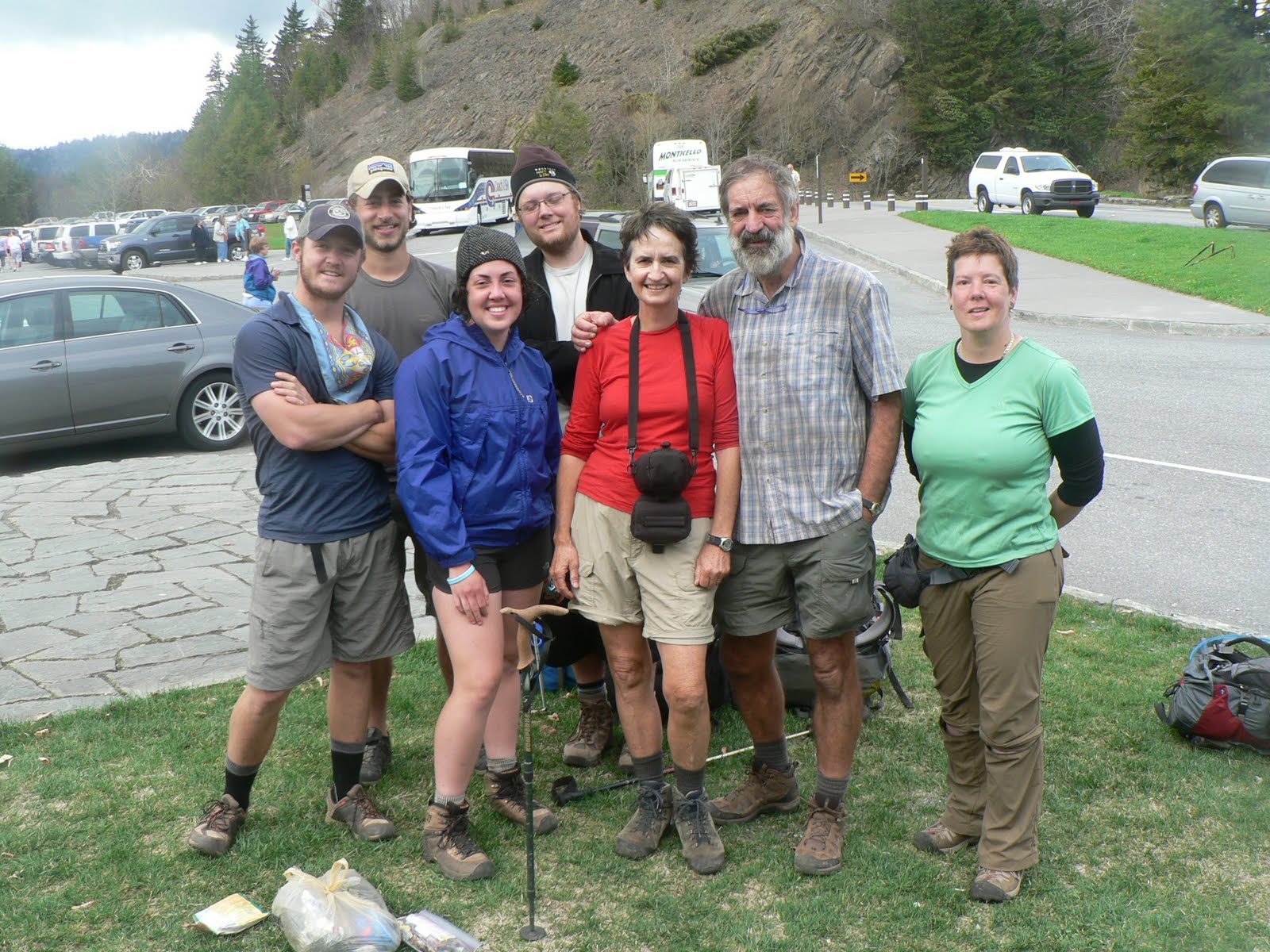
We arrive in Hot Springs and find Duckett House on the outskirts - an old large white country mansion. We look forward to the luxury of a hot shower and a soft bed. Hot Springs is our first 'trail' town - where the trail actually goes down the main street of town - we dont have to hitch a ride to get there. The town has recognised the hikers by using trail markers  in concrete along the footpath.

AT symbol in the pavement

The trail crosses the road and heads into Hot Springs

Duckett House - our B&B

After having a huge lunch at the local cafe - an ice cream soda and a grilled turkey sandwich - we spend a couple of hours at the Outfitters, and spend up on new boots for Alison, new parker, new merino longjohns and some interesting lightweight hiking meals. We are getting sick of Continental rice packets.

Time for new boots - no tread left

We spend two hours in the local library sorting out issues with our mobile phone via the internet. The library is full of hikers. The librarians issue laptops, and in every nook and cranny there is a hiker checking email or posting to facebook. At the post office, hikers are receiving food packages and the lawn outside is full of hikers spreading opem parcels out to sort out all the food they have been sent.

We head to the Railway Cafe for dinner and have a huge steak and a bottle of champagne - the first restaurant which we have found which is actually a licensed restaurant.

Friday, April 29, 2011

Day 29 - Roaring Fork Shelter to Deer Park Shelter - 14.7 miles

This is a wonderful hike through forest to climb to Bluff Mountain with great views. We are able to make good fast time. By the end of the day, we are footsore and tired - there is no campsite so we keep going until the shelter and arrive near dark.

There are about 6 other hikers camping here, but many others come through after us and keep on walking through to Hot Springs which is only 3 miles away to arrive late at night.

Thursday, April 28, 2011

Day 28 - 28th April, 2010 - Standing Bear Hostel to Roaring Fork Shelter - 15 miles

We leave Standing Bear in glorious sunshine and discover a rare orchid the Pink Lady Slipper on our first ridge climb.

The view across to the Smoky Mountains shows the snow on the mountain tops - we are glad that we were a day ahead of the bad weather.

Snow on the Smokies in the distance.
We meet two photographers who are orchid fanciers, hunting for Pink Lady Slippers. They had not been able to find any, so we gave them instructions to find 'ours'.
White blaze on the post marks the trail

Our hike turns out to be much longer than we planned because there is no campsite at the 13 mile mark, and we need to keep walking past our normal stopping time of 5.00pm. At the very end of the day we find ourselves climbing Max Patch, one of the most exhilarating 'balds' on the trail. As the sun is setting we find ourselves on the summit of Max Patch, with spectacular views. It is a bald - this means a big round hill with no trees - that someone probably in the dim dark past has cleared, and now National Parks keeps mowed. I find this amazing - I can't imagine Australian National Park staff mowing a bare hill to stop the trees revegetating.
Alison on Max Patch

We arrive after 5pm and lots of locals are walking their dogs. There is a really biting wind, and nest boxes are placed on posts in very exposed locations near the summit. I laugh - what sort of bird would try and nest here in this howling gale? Lo and behold, an Eastern Bluebird sticks its head out of the hole from inside the nest box. Then we discover that Eastern Bluebirds are rare. We are excited to see it.

Crossing the summit of Max Patch

Descending from the bald to the campsite is a long 2 miles. We start the descent with 'Rawley' -  we later discover his name is actually 'Raleigh' - we just couldn't understand his southern accent. Rawley heads off so quickly and misses the trail turn. Digby goes after him to tell him he has misssed it, but Rawley is travelling so fast that he is only a speck in the distance - we decide that perhaps he knows a shortcut that we don't know.

We arrive at Roaring Fork Shelter - we are the first hikers there - it is nearly 7.30pm. As the evening progresses another 6 hikers straggle in, including Snickers and Samantha, a single girl walking with a beagle called Toaster, and carrying a Macpac the same as mine. It was the only other Macpac I saw on the trail. Rawley arrives having retraced his steps back to the missed turn-off, and there is the couple we met on Day 1 with the American Bulldog, who insist on lighting a fire to cook dinner.

Wednesday, April 27, 2011

Day 27 - 27th April, 2010 - Davenport Gap Shelter to Standing Bear Hostel - 3 miles

This is a short day - in AT culture it is called a 'nero' - a half day of walking or less. We turn off to a hostel which is only 1 mile from the trail, in an old valley which was once a farm. The old homestead is now a very rustic hostel with hand hewn timber buildings.
Standing outside our room
Two things stand out in my memory - I was able to spend two hours on the computer - the first time on the computer in 3 weeks; and they ran a very small shop which looked like Aladdins Cave, using an honesty system. You write down what you buy on an envelope, put the money in the envelope and post it in the letter box. There is a great food selection.

Shopping for 3 days food in Aladdin's Cave
We have a pizza for lunch - they have a special pizza oven. You buy a frozen pizza and cook it for 15 minutes. The oven ran hot all afternnoon with a queue of people patiently waiting their turn.

But this place had serious drawbacks, mainly relating to environmental health issues. People smoking in the kitchen while others were trying to prepare their food. It was the only warm place on the property. The smoke was so thick it was horrible. I wondered if the Tennessee State had health inspectors who ever visited this place. There was one 'moldering' privy built over the the stream, and this was the only toilet for more than 40 people.

It was really packed that night - Crafty and Samantha, now called 'Snickers' - slept in our room on the floor. There was no heating and it was freezing. I was so glad that we were out of the mountains, as it would be snowing for sure.

Tuesday, April 26, 2011

Day 26 - 26th April, 2010 - Tricorner Shelter to Davenport Gap Shelter - 14.8 miles

We hike a long distance today. When we stop at Cosby Shelter for lunch Digby discovers that he has left his special reading glasses behind at Tricorner Shelter hanging from a rafter. We write a note in the shelter register asking people to keep an eye out for them and to contact us via our mobile if they find them. We never see them again.

The weather really closes in today, and the temperature plummets. Sleet, rain, and cold. We hunch up and walk as fast as possible, on a long descent following an old horse trail, with a gentle gradient, and leaving the National Park. We stop at Davenport GapShelter and spend the night with Fireball and two old guys who are heading south into the Smokies. The wind blows through the gaps in the rafters - it is a very cold wet night.

Monday, April 25, 2011

Day 25 - Icewater Shelter to Tricorner Shelter - 13 miles

We wake up to a shelter which is absolutely jam-packed with hikers. Most of them are weekend hikers. We eat breakfast, pack and leave quickly.


Alison is on the right wearing a red parka


Today with blue skies and sun, we cover 13 miles and are so impressed with ourselves.

The hike is beautiful - we are following a razorback ridge which is the border between North Carolina and Tennessee. We can stand astride the state boundaries. We walk through dark conifer forests, covered with moss - lord of the rings stuff.
This trail was cut in the 1930s by the conservation corps - unemployed men working
on an unemployment scheme by roosevelt i think.


Look at the size of this pack.

The only other hiker we see for the day is Fireball, a young German man who tells us he is studying maths at university and had to stop his studies to do 9 months of military service. He saw a documentary produced by National Geographic on the AT, and this made him decide to do the hike.

Two miles from Tricorner shelter and I sprain my ankle - just a quick twist with serious ramifications. I hobble slowly into the shelter, and soak the ankle under the spring. There are only four other hikers staying there with us tonight. After the crowded shelter last night this is a welcome relief. Two thru hikers - Paradise and Kindling who we have got to know, as well as a new hiker 'Tennessee', an older man walking all the trails of the Smoky Mountains National Park. We give him our spare map.

Sunday, April 24, 2011

Day 24 - Mt Collins Shelter to Icewater Spring Shelter - 7.5 miles

A leisurely start for a short day with bad weather forecast with thunderstorms. We head off from the shelter and are passed by everyone else. An easy graded walk mainly downhill descending to Newfound Gap. Newfound Gap is a shock - people, cars, buses, and hundreds of day trippers. The highway crosses the Smoky Mountains at this point - it is the only place where cars can access the national park.
Arriving at Newfound Gap

Thru-hikers at Newfound Gap

'We are here' - the sign shows the AT trail marked for the full distance.
We have walked just a few inches!
The highway drops down to a town - Gatlinburg. The description of Gatlinburg as a tourist town offering a 'disney' experience makes us decide to continue on the trail at this point. We leave Mandog, Pocohontas Mode to hitch a ride to town. We never see Pocohontas Mode again - I had really enjoyed her company. She is one of the 90% of thru-hikers who start and do not complete the trail.

We climb up the mountain from the gap, passing many tourists, with our heavy packs and steady rhythym. The weather starts to close in as promised. We make it to the shelter before lunch, and then the temperatures drop and the rain starts. There are two thru-hikers already at the shelter - an old man of 79 and his son, who also spent last night at the shelter . They have lit a fire and are cooking up tortillas and melted cheese. During the afternoon, more hikers dribble in through the wind and rain. We snuggle down into our sleeping bags and fritter away the afternoon.

By 6pm there are no more spaces on the bunk platforms - about 12 people on the top layer and 12 on the bottom. The rule in the Smoky Mountains National Park is that all hikers must book to stay in a shelter. There are 4 spaces left unbooked for thru-hikers. The rule is that if the shelter is full, with booked people,  the 5th thru-hiker  has to vacate the shelter and set up camp. All thru hikers carry tents. The reality is very different - as the weather closes in, and the bodies increase everybody keeps squeezing up to make room to fit them in.

We are woken up at 10pm by a young man in his 20s arriving with his mother - poor mum - she has hiked in the dark in freezing temperatures and heavy rain and mist for 3 miles to this shelter, trusting her son to look after her. The group all squash up and squeeze them in. At around midnight another group arrive. Everyone is asleep, squashed in like sardines. The latest group have to sleep on the dirt floor.

Saturday, April 23, 2011

Day 23 - Derrick Knob Shelter - Clingmans Dome - Mt Collins Shelter - 13.5 miles

The highlight of today is clocking over our first 200 miles of the trail, and climbing Clingmans Dome. This is the longest day on the trail for us so far.

We lunch at Double Springs Shelter with Food Network - his boots are in an appalling state, held together with duct tape, the basic tool of the hiker. He is not feeling good, with numb muscles and decides to take a break here. He has managed to make a call on his mobile phone to ensure that new boots will be ready for him in Gatlinburg, but there is a weekend between him and his boots. He is in no rush. We are sad to leave him behind, as he is a great entertainer. 

The final climb to the summit ridge of Clingmans Dome

It is a steady climb up to the dome. There are great views from the top - the highest point on the AT, at 6643'. There are no tourists on the tower as the road is closed for repair. coming up from the tourist car park is Stickbuilt - he is not happy. The signpost marking the trail to the summit has been turned around and he has followed it downhill for a mile, and then realised his mistake and retraced his steps.


Clingmans Dome Tower

The Clingmans Dome tower is a space ship design and makes us feel like aliens from another planet - no people, dead trees - and silence. Except for Tater Chip calling for Stickbuilt. The call echoes out over the forests.

Dead conifers caused by air pollution from Tennesse coal fired power stations

Tripper and Wizard at the summit

Descending from the summit on the northern side away from the sun, we experience our first snow drifts. We don't know it at the time, but the weather is deteriorating, and in a few days the Smokies will be covered in snow, with many hikers unprepared for the cold, wet conditions

Snow drift - our first snow in USA
We are totally exhausted by the time we reach the shelter which is half a mile off the trail, which makes it even worse, knowing that we have to retrace our steps back to the main ridge. It feels like a lot more than half a mile.

At the shelter we meet our first ridge runner, 'Flying Squirrel', a small muscley young woman whose real name is Kerry. We meet her again in Vermont, supervising an all female track building team, but that is a long way in the future.

The weather report is for bad weather. Two section hikers at the shelter decide to abort their hike and offer their pancake mix and accoutrements to the through hikers. Through hikers never turn down an offer of food on principle - we are always hungry! Digby makes pancakes for 10 people using the lid of his cooking pot, and served with honey, oil and strawberries. There is no snoring in the shelter that night - amazing.

Friday, April 22, 2011

Day 22 - Mollies Ridge Shelter to Derrick Knob Shelter - 12 miles

This is a terrible day - really hard, really difficult ups and downs which seem to go on forever.


Wildflowers are erupting everywhere. Digby is amazed that 'triliums' exist as real plants, are not just a sci-fi quest. The shelter provides us with our first view of chipmunks - they move really fast and are really jerky in their movements. We catch them out of the corner of our eye.

There is dead forest everywhere - trees uprooted from huge storms. Conifers are dying from insect attack after being weakened by atmospheric pollution. This is particular sad, when you read the history of how people in the 1930s fought to protect them against powerful logging interests. The pollution comes from the power stations in Tennessee and we read that they are now trying to control the levels.

 
We pass the Russell Field Shelter, which has a bear cage at the front to keep the bears out and the hikers safe. They don't build these cages anymore - they ask hikers to take their food away from the shelter and hang it from a tree.
Alison and Pocohontas Mode at Russell Field Shelter in the cage


Pocohontas Mode


Wizard from Oz, Pocohontas Mode and Tripper
We enjoy the company of 'Pocohontas Mode' a young woman we have seen regularly on the trail since about Day 5. We overhear her calling her mum on her mobile phone 'Today I walked 19 miles, yesterday I walked 21 miles, etc etc.' We are surprised that she is still in our cohort of hikers, given how fast she can walk. I ask her why the trail name of 'Pocohontas Mode' which does seem a trifle strange. She replies 'When I am hiking I go into the zone - I feel at one with the landscape, like an Indian - I call it my Pocohontas mode.'
Derrick Nob Shelter - two levels of sleeping platform and a fire.
Hang the packs to avoid the mice.
We have a great social evening in the shelter, singing along with Food Network playing his ukelele. He had learned the chords for Waltzing Matilda, which he had downloaded at Franklin, and Digby sang the words. There were three older women who had nearly finished their AT hike which had taken them nearly 10 years doing a section each year. They had great voices and knew the words of every song sung in a musical in the past 50 years. The sound boomed out from the shelter. We never had another night like this one. It was very memorable.

Thursday, April 21, 2011

Day 21 - April 21st - Fontana Dam to Mollies Ridge Shelter - 12.1 miles

This is a really hard day. We are driven back down to the trail by Mike from Hikers Inn. He gives us 'the lecture' and I think we got a bit extra as well - 'the international hiker' version - to scare us to death. I don't remember much of it except to 'shake out your boots before you put them on or poisonous spiders will bite you'.

We cross the dam wall, enter the Smoky Mountains National Park and climb the ridge called the Shuckstack. By lunchtime we have ascended 2,000 ft. This is followed by another 1000' of climbing over the afternoon. We climb slowly in a steady rhythym, and are passed by Turtle hiking with Mellow Yellow, Mr T and Food Network and Paradise.

Alison crossing the dam wall into the Smoky Mountains

We arrive at the observation tower for lunch. Digby climbs it. I make it to the first landing and decide the exposure is too scary. The views are spectacular on a sunny day. Then there is a long drag to the shelter which never seems to arrive. We are exhausted.
View of the ridge we have just climbed in the middle foreground and Fontana Dam
from the observation tower.

Half a mile from the shelter and I see my first Black Bear, only 30 metres in front of me on the track. It is huge and runs off 30m into the bush. I show Digby, and he sees it too. We look at the bear through the undergrowth and the bear looks at us. We stay locked in this position for about 10 minutes and then the bear ambles away. Very fluffy, and like a giant panda. I am thrilled and excited - first bear for the trail. When we get to the shelter nobody else had seen it, so we felt very honoured. Bears are protected in the National Park but in the surrounding forests they hunt the bears with packs of dogs. This cruelty is something I find really difficult to stomach. In Maine the so called hunters set up baits for bears - stale donuts from 'Dunkin Donuts' fast food chain, wait for the bears to come in to eat the donuts and shoot them. And this is all officially sanctioned.

Mollies Ridge Shelter is very luxurious and we meet up with a lot of hikers that we already know. 'Paradise' is there. We meet 'Stickbuilt' and 'Tater Chip' for the first time, and learn the names of a very fast young couple - Dewlap and Rainer - who had passed us before, and meet Fireball, a young German who was given his trail name when his camp stove exploded.  There is a big fire and everyone is asleep by 9.00pm. This is our first night sleeping a shelter. In the Smoky Mountain National Park there are rules - up until now hiking has been fairly easy with few restrictions. In the Smokies you must stay in a shelter, not a tent to reduce the damage to the vegetation.  No dogs are allowed - hikers with dogs have had them collected by boarding kennels for the traverse.

Mollie Ridge Shelter

Hikers at Mollies Ridge Shelter

Wednesday, April 20, 2011

Day 20 - 20th April, 2010 - Cable Gap Shelter - Fontana Dam - 5.5 miles

By the time we are ready to leave the campsite at 8.15am it is already deserted. We climb 700' and descend 2000' and make good time to arrive at Fontana Dam at 11.30am. There is a pay phone and we call the Hiker Inn, an old motel, which is located about 6 miles away, to come and collect us. We are going to spend a night in luxury.

While we are waiting, an older lady comes up to chat and said she had taken two young women hikers out for dinner the previous night. It turns out to be Crafty and Sam. So we know that they are one day ahead of us.

Turtle had told us that we were making good time to be at Fontana Dam by Day 20. For the average through hiker it is 19-21 days to get here. This is amazing as we thought we were miles behind everybody else. Turtle also said that the mountains of Georgia and North Carolina are some of the hardest on the trail, and that the section from Nantahala Outdoor Centre to Fontana Dam is the hardest section of the south. So we are still alive and in with a chance it seems, to complete the hike in our time frame. On Digby's schedule, we were down to arrive at Fontana on Day 15! so we are now 5 days behind the planned timetable.

The hosts of Hikers Inn are very friendly. Nancy has five dogs, that she has rescued over the years. They all have a history of abuse and neglect.I stick my head over the back fence to say hello and one of the dogs, a rottweiler with very short legs nearly bites my head off.

We luxuriate in the motel room, and watch TV - the weather channel - and discover that rain has set in for the day but is meant to clear for the next 3 days followed by lightening storms.

Nancy does our washing for us and we order burgers and chips from the local takeaway which she collects for us. We spend the afternoon watching TV, eating junk food and relaxing in the warmth of the room, with the heater turned uphigh.

At 5.00pm Nancy drives us into Robinsville a town about 15 miles away and we shop at a large supermarket for 6 days food, and have a Mexican meal at the local restaurant.

Although we dont actually meet them at this time, Stickbuilt and Tater are also staying at the motel and also have been taken to Robinsville to eat at the same Mexican restaurant.

This is one of those days where the camera never made it out of the pack!

Tuesday, April 19, 2011

Day 19 - 19th April, 2010 - Locust Cove Gap to Cable Gap Shelter - 12 miles

Digby takes lots of photos of wild flowers today, as Spring is starts in earnest.
Digby thinks this is a violet

 A long hard day, with a killer climb straight up to the knoll - from Stecoah Gap there is 700' of climbing after 'Sweetwater Gap', and it nearly killed my ankle being bent at such an extreme angle on the slope. This climb would remain as one of the steepest on the whole trail.

We meet 2 elderly ladies, hiking in their late 60s, and doing a thru hike - 'Convinced' and 'Breathless', and quite a few single male hikers that we call 'lone wolves' as they are moving very fast and never stop to talk.

When we arrive at Cable Gap Shelter it is very crowded, lots of tents and no flat spots left. Turtle arrives and so does Mr T. As the evening progresses, more and more hikers roll in. One young couple rest for half an hour and then depart to walk another couple of hours.

Cable Gap campsite - I am waving from the front tent.
Shelter is in the background.

This is a significant night - we meet Kindling, and Paradise, two single men who cross our paths for the next month, and become good friends. Stickbuilt and Taterchip also camp here with us but they arrive so late and leave so early that we do not meet them, for another few days.

Monday, April 18, 2011

Day 18 - Nantahala Outdoor Centre to Locust Cove Gap - 10 miles

A very steady steep climb for 4 hours. We climb from 1500' to 5000' to reach Cheoh Bald around 1pm.On the ascent we pass a plaque commemorating a firefighter who was killed in the area trying to stop a forest fire.
Plaque to commemorate a fire fighter
Lazy afternoon on the summit of Cheoah Bald


Half an hour rest basking in the sun

Cheoh Bald is a brilliant viewpoint. The weather is sunny and I lie and bask in the sun for half an hour and let the warmth seep into my bones, before we head don to the gap to camp.

We make camp and have a fire - something of a rarity, and the first time we have actually lit one. We are joined by 'Low Key' and a father and son who do not interact but put up their tent and go to bed.

Sunday, April 17, 2011

Day 17 - Tellico Gap to Nantahala Outdoor Centre - 7.9 miles

The hike is short, but a very long descent, over 2500'. On the way we meet a volunteer track maintainer, called 'The Geek' doing his patrol. He is allocated a section of trail to look after, and he walks this section on a regular basis, pruning back the vegetation, and removing fallen trees. He is the first of many volunteers that we will meet over the next 6 months. The AT owes its survival to the support from volunteers and community groups. We are amazed at how many people are involved in track building and maintenance and wonder if this model could be applied in Australia.

As we approach the Nantahala Outdoor Centre (NOC) we can hear loud microphones and music floating over the ridge. There is a busy festival and demonstration of canoeing taking place on the river, with a slalom couse, loud music, and hundreds of people and cars.

We are lucky to be able to get accommodation at one of the lodges, and then we head straight for the outfitters. We had bought a battery charger for our camera on the internet and had it mailed to us here - and there it was! We had lunch at the riverside restaurant - fresh trout and salad, with a glass of californian chardonnay. The glass is 'big'.

Life is tough - riverside dining for lunch and dinner

It is a relaxing afternoon in the sun. We sit and drink beer with the other hikers, and meet Traveller again. We havent seen him since Day 1. Traveller joins us for dinner later that night and we hear his story - he slept rough the first night as he did not make it to the campsite, and then turned around and went back. He decided he needed lighter gear, did a complete refit, and then started hiking again from Neals Gap, so he jumped a few days ahead of us.

Digby with Traveller
Digby went shopping in the outfitters for a new pair of boots - and buys a very light pair like gym shoes which breathe - this means they have holes and the water gets in.

We drift off to sleep listening to 'hillbilly' music - great fiddle playing coming from the beer tent by the river.

Saturday, April 16, 2011

Day 16 - Wine Spring to Tellico Gap - 11.3 miles

We climb to Wayah Bald, and the John B Byrne Memorial Tower on the summit (5,342'). John Byrne started the Conservation Corp during the depression, built the tower, re-afforested the mountains and then died at the age of 37 from a collapsed lung caused by poison gas in WW1.

Digby reads the log book at a shelter


Wayah Bald

John Byrne Memorial Tower

View from tower

The highlight of the day is arriving at Burningtown Gap to discover a 'soiree' as Jamie had described it, and warned us of what to expect. As we come down the mountain we see tents and cars.

Burning Gap - Trail Magic - Incoming hiker

Hiker drinking beer from portable cup

Someone spots us and calls 'incoming'. As we arrive we are greeted - "What would you like? a burger? with cheese? a hot dog? If you have a cup there is a barrel of beer. Cakes are in the icebox over there, help yourself. So we stayed for an hour and gorged ourselves.

Turtle is here - the hikers putting on this trail magic are old friends of hers. After an hour Digby wants to leave and get moving with more miles under our belt before dark. I would have been quite happy to stay and while away the afternoon, and camp there for the night. Many hikers did this - we hear later there is a sea of tents.

We press on and leave the food and company behind. We hike down the ridge to Tellico Gap, where there is no campsite but we camp in a sheltered spot in the car park, by the road. Around midnight a truck drives up, leaves the engine running. We lie in the tent wondering if we are going to be shot in our sleeping bags. He finally turns the engine off and we hear 'bear bells', tinkling bells that dogs wear to frighten or warn bears.

Campsite at Tellico Gap

Friday, April 15, 2011

Day 15 - Winding Stair Gap to Wine Spring - 8.5 miles

We catch the 11.00am shuttle from Franklin to take us back to the trail. In the office of the motel there is a free computer with internet. We check our email and meet Food Network who downloads a copy of Waltzing Matilda with chords, so that he can play it on the banjo that he is carrying on the trail. We leave Jannie behind at the  motel, and don't see her again.

Before we depart from Franklin we chuck our 'itinerary' in the rubbish bin. This is a laminated document we have carried from Australia, telling us where we should camp, every night for 6 months to enable us to complete the 2185 miles in the 6 month time frame that we have for our visa. Digby has worked out that we need to average 12.5 miles per day, every day. Here is a cut and paste from this document


At the beginning of day 15, April according to our planned schedule, we are meant to have already walked 161 miles. Our timetable bears no resemblance to reality. We made it to Hiawassee on the 10th April, 3 days behind our planned schedule. Franklin did not even make it on to our itinerary. It is the start of day 15 and we have only walked 107.6 miles from Springer Mountain.  We are 53.4 miles behind our planned itinerary. This is approximately 5 days behind schedule. Chucking the itinerary in the rubbish bin is a very uplifting and mind releasing moment. We are now walking in the moment. Forget the schedule. Concentrate on each day and do what we can - if we don't make it so be it. This is a major mental achievement. The laminated itinerary is also quite heavy - 4 pages of laminated paper - I am now at least 100gms lighter in my load. We are hoping that as we get fit we will catch up on the mileages that we are behind. At the moment we cannot walk 12.5 miles in one day - but the theory is that as we get fitter we will be able to increase our distance and make up for lost ground. There is no point stressing about it. We decide to just walk.


It is a hard slog up to the campsite. The last mile is a killer. It is getting darker and trying to rain. We can feel the temperature dropping. We share the campsite with Jamie, from Maryland, who makes a living selling mortgages, except no-one is buying mortgages at the moment, with the Global Financial Crisis still underway. With business so bad he decides to walk the trail. We give him the trail name of 'Tea Cozy', for his beanie that he wears.

Cooking dinner